

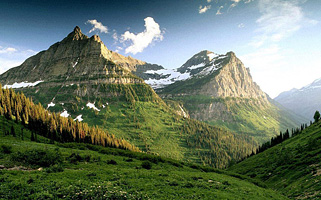
Mount Uludag (Great Mountain) is 2543 meters high, making it the highest point in the Marmara region, and the Aras Waterfalls and glaciers at the peak are its most interesting geographical features.
Uludag National Park, 36 km south of Bursa, is one of the Turkey’s favourite winter sports centres and as well as skiing, its richness of flora and fauna has made it into a National Park and summer activities like trekking and camping are also popular. Uludag was previously known as Olympos Misios in ancient times, and is known in mythology as the place where the gods watched the Trojan war. Plans have been confirmed for a development project, which will offer a huge increase in accommodation and skiing facilities.
Uludag National Park is the leading center for winter sports and skiing.
Being the Turkey’s most important center for winter sports and skiing, the number of days Mount Uludag is covered with snow is 178 days. Due to its proximity to large residential areas and the mass amount of camping and daily use, Bursa satisfies the recreational needs of the nearby cities. The annual visitors of Uludag National Park are close to 1,000,000 people. It is 36 km away from Bursa and 150 km from Istanbul. And the ski center‘s distance from the airport is 60 minutes and from Bursa is 40 minutes.
The highest peak of Mount Uludag is Kartaltepe at 2543 meters. It is covered in forests, and the region has a partially temperate climate with a dominant wind direction of south-west/south. The altitude of the skiing area is between 1750 – 2543 meters, and the best season is from late December to late March. The snow at the beginning of the season is powdery, getting increasingly slushy towards the end. To the north are other high plateaus: Sarialan, Kirazliyayla, Kadiyayla, and Sobra.
Both cross-country skiing and Alpine skiing is available at the Uludag centre. Although facilities are not exceptional, they are more than adequate, with a chair lift, three separate ski lifts, experienced instructors, slalom runs, and a number of shops hiring all of the necessary equipment.
In the summer
Uludag National Park an is very popular with tourists and day trippers. Uludag (Great Mountain) is within a national park, there is easy walking up the gentle slopes, beautiful glacial lakes and forests and Alpine meadows to picnic by, plenty of hotels, cable cars and fantastic food.
In the winter
Uludag National Park is transformed into a very popular and busy ski resort. Snow can be up to 4 meters. National Park can be reached both by highway and cable car. The Ski resort is 40 minutes away from Bursa by road and 60 minutes from the airport. Travelling by private vehicle, the Cekirge road is the easiest. Drivers must keep wheel chains, wedges and heavy ropes during winter.
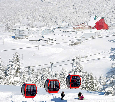 There are four sections of the cable-car route to reach Mount Uludag , two between Bursa and Kadi plateau (1235 m) and two between Kadi and Sarialan (1621 m). Each line has a cabin that can fit 30 people, although it is prohibited to carry ski equipment, and depart the district of Teleferik every 20 minutes. The journey, which stops at Kadi and then changes car, takes around 25 minutes. From the Sarialan, there is a minibus service travelling the last 7 km to the hotel area. In the summer season, there is a chairlift from Sarialan to Cobankaya (1750 m)
Uludag National Park mountaineering
There is a number of hiking trails on Mount Uludag with the most popular being the trail through the forest from Sarialan to Cobankaya and the trail above the treeline to the glacial.
History
Mythological name of Uludag which gave its name to the National Park is Olympos Misios. During the Ottoman Empire, Uludag was known as Kesis Mountain and it received today’s name of Uludag in 1925.
Uludag is one of the 122 important plant areas in Turkey
Uludag National Park, has extraordinary natural beauties, forests, rich flora and fauna . 71% of the National Park is forest, 28% is meadowlands and rocky areas (Alpine Region), 0.4% is open areas, 0.1% is covered with water and 0.8% of it is a residential area.
Uludag National Park has rich flora that has both Alpine and endemic plants specific to Turkey and Uludag. There are 104 endemic species detected in Uludag and 32 of those are Uludag endemics. There are 46 species of butterflies living in the Uludag National Park as well as having an Uludag specific endemic breed of Apollo butterfly (Parnassius Apollo L.).
 The rich vegetation of Uludag is caused by its location between the Mediterranean and the European-Siberian floristic regions. In its flora, there is 63% of Euro-Siberian element and 31% of Mediterranean element. It is also known that in Uludag’s flora, there is a %6 of Iranian-Turanian floristic element as well. In addition, Uludag is one of the 122 important plant areas in Turkey.
Different species such as bears, coyotes, fox, squirrels, rabbits, weasels, wild boars, snakes, lizards, mountain eagles, woodpeckers, owls, doves and sparrows continue to live in the Uludag National Park. Bearded vulture (Gypaetus Barbatus) is one of the endemic species found in National Park. In addition, the red forest ants provide huge benefits to the Uludag National Park by eating all the harmful insects in the forests. Uludag has been identified as an Important Bird Area due to its hosting of the breeding population of the bearded vulture and mountain eagles.
The Forest Zones in various heights and for these forest zones to be seen during a 45 minute car ride, the Uludag National Park has particular scientific importance in the world forestry literatüre. These are Laurentum, Cantanetum, Fagetum, Pinatum, Albiertum and Alpinetum generations.
During the journey from Bursa towards the peak, over 700 species of herbaceous and perennial plants such as Bay Leaf/Laurel, Common Alder, Sycamore, Judas Tree/Redbud, Chestnut, Linden, Maple, Prunus Lauroceraus, Hazelnut, Oak, Beech/Fagus, Aspen, Cranberry, Larch/Black Pine, Rowan, Fir/Abies, Bearberry, Dwarf Juniper, various herbs and lichens can be seen and various different plants can be discovered at Uludag which is one of the rare places with rich diversity of plants.
Uludag National Park lakes and Aras Waterfall
At the peak of Mount Uludag, there are 9 glacial lakes which dry out during summer months. The most important of these are Karagol, Kilimli lake, Buzlu lake and Aynali lake that are located at the lake regions.
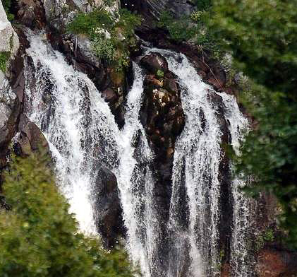 Aras Waterfall; If you take the Uludag road from Bursa and turn onto the asphalt road that leads through the forest when you come to the entrance of the Uludag National Park, you will come to the village of Soğukpınar at an elevation of 1000 m. The 30 km from Bursa to Soğukpınar is asphalt but the 5 km to the Ketenlik Highland is gravel. From the highland village of Ketenlik take the marked trekking trail north and you will find the Aras Brook and Waterfall in a rocky area full of the water from the melting snow of Uludag and falling from a height of 15 meters. The elevation here is 1700 meters.
Uludag is a Granite Batholith and has gained its today’s appearance from Technotic movements. The first traces of glacial period in our country have been identified in Uludag by Phlippson. On the slopes of Uludag facing north, there are formations shaped by glaciers and interesting looking rock formations.
The Sarialan Camp Daily Use Area has a 300 tent capacity and also is open for visitors with its countryside clubs, barracks, bungalows, souvenir shops, utility complex, restrooms, wellness trail, children’s playground and a mosque. With a 150 tents capacity, Cobankaya Camp Daily Use Area is open for public with its convenience store, utility complex, restrooms, children’s playground and al-masjid.
2 kilometers away from Cobankaya, the Bakacak site is the best place to be for a panoramic view of Bursa.
Kirazliyayla Daily Use Area has restrooms, soccer field and children’s playground along with two accommodation facilities owned by official institutions.
Uludag National Park entrance door is by the Karabelen Daily Use Area along with its having restrooms.
There is currently a hiking trail within the Sarialan Camp and the Daily Use Area. The length of the ‘’Live Young Trail’’ which has been arranged in the forest area is 2.1 kilometers. The trail consists of 10 exercising stations that are arranged in accordance with the scientific and medical principles.
Bursa
Bursa, the 4th biggest city of Turkey, is located on the north-west skirts of the Mount Uludag and the south-east of The Marmara Sea. Bursa is settled on the north-west slopes of the Mount Uludag in the South of Marmara Region. It is bordered by The Marmara Sea and Yalova on the north, Kocaeli and Sakarya on the north-east, Bilecik on the east and Kutahya and Balikesir on the south. Bursa was founded and developed on the slopes of the Mount Uludag. Since it is a convenient place for defence, the first settlement was on the rocks of the slopes. After the city was captured from the Byzantine Empire, many structures were built especially when it was the capital city of the Ottoman Empire.
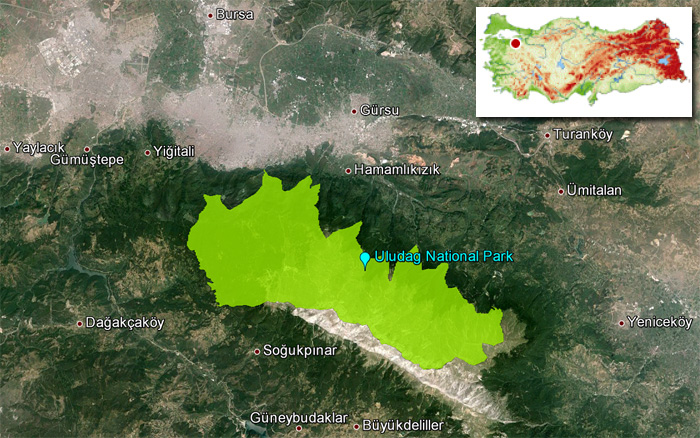 Uludag National Park Map


