

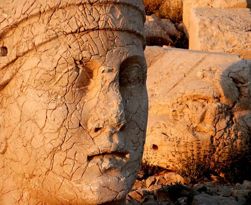
The colossal stone heads at the top of 2150 meters high Mount Nemrut National Park are one of Turkey’s most famous sites. The statues of Greek and Persian gods were thirty-three foot tall and formed part of the tomb and temple complex built by Antiochus I ( 69–34 B.C BC), who reigned over the Commagene kingdom. In addition, it is also the site of tumulus of Antioch, Eskikale (Arsameia), Yenikale (New Castle), Karakus Tepe (Peak), and Cendere Bridge.
Nemrut: Throne of the Gods
A magnificent historical site located on the eastern Taurus mountain range and the 8th Wonder of the World bearing the most valuable monuments of the Kingdom of Commagene. The Nemrut is a mountain of the Taurus Range, in Adiyaman. Mount Nemrut National Park is a mountain measuring 2150 meters in height and the surface area is 13.850 hectares. It is located near the Kahta village in the province of Adiyaman. From a height of 2150 metres it dominates the entire landscape. From whatever side you approach it, its distinctive peak can be seen. The mountain is only accessible during the summer months. The rest of the year it is covered by snow and ice.
Area Profile
Provinces: Adiyaman
Towns: Kahta, Karadut
Coverage Area: 13.850 Hectares
Coordinates: N38 2 11.796 E38 45 49.284
Height: 2150 Meters
History
 Kings of the Kommagene dynasty from 80 B.C. to 72 A.D ruled Adiyaman and its vicinity. This kingdom, whose capital was Samosata (now called Samsat), was founded around 80 B.C. by Mithridates 1, father of Antiochos 1. The kingdom’s independence came to an end with its defeat by Roman legions in the last of the Kommagene wars and it became part of the Roman province of Syria. At its height, Kommagene extended from the Toros (Taurus) mountains on the north to the Firat (Euphrates) river on the east and southeast, to present-day Gaziantep on the south, and to the county of Pazarcik in Kahramanmaras on the west.The magnificent ruins on the summit of Mount Nemrut are not those of an inhabited site however. They are instead the famous tumulus (burial mound) and hierotheseion (a word that is derived from Greek and refers to the sacred burial precinct of the royal family, and whose use is known only in Kommagene) of King Antiochos I of Kommagene, who ruled from 69 to 34 B.C. In a cult inscription, King Antiochos declares that he had the site built for the ages and generations that were to follow him “as a debt of thanks to the gods and to his deified ancestors for their manifest assistance”. The king also declares that his aim was to provide for the people an “ex- ample of the piety that the gods commanded be shown towards the gods and towards ancestors. “Professor K. Dorner has traced the genealogy of Antiochos 1, who was himself born of a Persian father and a Seleucid-Macedonian mother. His findings indicate that Antiochos I of Commagene claimed descent, through his father Mithridates, from Dareios (Darius) 1 (522-486 B.C.) and, through his mother Laodike, from Alexander the Great (356-323 B.C.) Mt Nemrud is located 100 kms from Adiyaman. No reference is made to it in ancient sources.
Karl Sester, a German road engineer, rediscovered it in modern times in 1881. An expedition to Mt Nemrud was organized in 1882-83 by Karl Humann and Otto Puchstein, who published their findings in a book entitled Reisen in Kleinasien und Nordsyrien (Berlin 1890). Osman Hamdi Bey and Osgan Effendi also investigated the site in 1883 and their findings were published in a book entitled Le Tumulus de Mount Nemrut (Istanbul 1883). F. Karl Dorner and Rudolf Naumann mounted an expedition to Mount Nemrut in 1938. Dorner returned to the site after 1951 and began working there with the US researcher Teresa Goell. In 1984, a Turkish-German team led by Professor Dorner successfully carried out restoration work at the site. Excavation and restoration work has been continuing since 1989 under the direction of Sencer Sahin. In 1988, Mount Nemrut and its environs were declared a national park. The tumulus on the summit of Mount Nemrut measures 50 meters high and covers an area 150 meters in diameter. It is formed from stones the size of a fist and is bounded on the east, west, and north by terraced courts carved out of the native rock. The eastern court was the center of the sacred precinct and is the most important group of sculptural and architectural works. It is surrounded on the west by colossal statues, on the east by a fire altar in the shape of a stepped pyramid, and on the north and south by low walls of orthostats (upright stone slabs) standing on a long, narrow base.
The ruins on the top of Mount Nemrut
The ruins on the top of Mount Nemrut indicate that it was not a residence, but specifically built for the tumulus of Antioch and his sacred space. The tumulus is at an altitude of 2150 meters and overlooks the River Firat and the neighbouring plains. It is thought that the king’s bones or ashes were put inside the room carved into the main rock, then covered by the tumulus which is 50 meters high and 150 meters in diameter. The courtyards are shaped like terraces, and religious ceremonies were held on the western side of Mount Nemrut National Park.
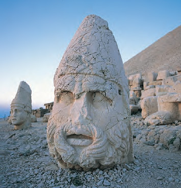 On both terraces, the huge sculptures of the gods, measuring up to 7 meters high, are positioned between the lion and eagle sculptures. These are surrounded by great stone blocks, arranged perpendicularly with inscriptions and embossed designs. The capital city of Commagene, Arsameia, is in the neighbourhood of the old Kahta village. The holy field of Mithridates is also in that area.
Yenikale is also of great historic interest, and in the area of old Kahta. This castle was built on very steep rocks, and has water depots, baths, mosque, and a hidden water road that leads to river Kahta.
Cendere Bridge, built with one arch on two rocks, crosses the narrowest point of the river Cendere. According to the epitaph written on the columns of the bridge, the Commagene cities had built it in honour of Roman Emperor Septimus Severus (193-211 AD) and his wife and sons. Karakus Peak Tumulus, in which the women of the royal family were buried, is a 21 meters tall tumulus 10 km south-west of Arsameia.
UNESCO World Heritage List
Cultural components of the site are protected under the National Conservation Law No. 2863 and National Parks Law No. 2873. Mount Nemrut Tumulus was registered as a First Degree Archaeological Site under Act No. 2863 in 1986. After the preparation of current detailed maps, this site was revised and its surroundings were designated as an Interaction Transition Zone by Sanliurfa Regional Council for Conservation of Cultural Property in 2008. Finally, the border of this zone, which acts as an unofficial Buffer Zone, was enlarged in 2011 by the same authority for the sake of the conservation of the cultural asset. UNESCO has inscribed Mount Nemrut on the UNESCO World Heritage List in 1987 and called the site the 8th Wonder of the World. Under the National Parks Law (No. 2873), an area that includes Nemrut Tumulus and other archaeological areas covering 13.850 Hectares were declared a Natural Park in 1988.
Sunset on Mount Nemrut National Park
Many of the Mount Nemrut National Park tours will include sunset cocktails at the site, as the statues at Mount Nemrut are quite an extraordinary sight as the sun sets and under the brilliant night stars in the mountain air. There are hotels and restaurants available near the national park, Karadut and Kahta.
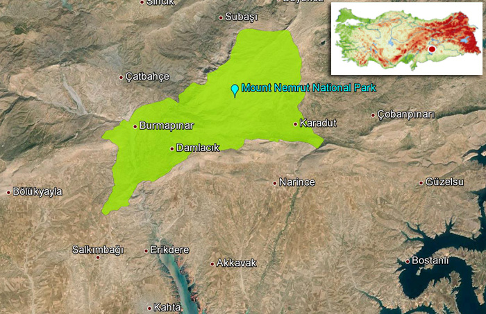 Mount Nemrut National Park Map


