

Goreme (Göreme) Historical National Park
Goreme (Göreme) Historical National Park, located in the volcanic zone of Hasan Mountain and Erciyes Mountain is formed of plateaus, plains, small mountain plants, high hills, alluvial stream and river valleys, drainage deltas and eroded steep valleys and high flat areas. Found in a spectacular landscape, entirely sculpted by erosion, the Goreme valley and its surroundings contain rock hewn sanctuaries that provide unique evidence of Byzantine art in the post iconoclastic period. Dwellings, troglodyte villages, underground towns, and the remains of a traditional human habitat dating back to the 4th century can also be seen there.
 The defining features of Goreme Historical National Park in Cappadocia, central Turkey, are unusual rock formations known as “fairy chimneys.” These natural wonders are augmented by the cultural heritage of the region’s inhabitants, who as far back as the third century hewed homes, churches and entire underground cities into the landscape.
Goreme National Park on the UNESCO’s World Heritage List
Goreme National Park and the Rock Sites of Cappadocia, added to the UNESCO World Heritage List in 1985 on natural and cultural criteria. This rocky landscape is honeycombed with networks of ancient underground settlements and outstanding examples of Byzantine art.
UNESCO Identity Card
Official Name: Goreme National Park and the Rock Sites of Cappadocia
Date added to UNESCO List: 1985
Type: Cultural, Natural
Reference: 357
Location: ehir Province (Cappadocia) in Central Anatolia
UNESCO Region: Europe and North America
Coordinates: N38 40 0.012 E34 51 0
Property (ha): 9,884
Height: 500 m
Geographical Location
In Nevsehir Province of Central Anatolia, between Nevsehir city and the towns of Avanos and Urgup. Goreme Historical National Park circumference is approximately 40 km, extending from the bridge at Urgup then leading north for 6 km following the River Damsa. The boundary then heads west, immediately to the north of Zelve and south of the River Kizilirmak, by Avanos to Toprak Hill.
The Rock Sites And Underground Cities of Cappadocia
Cappadocia which is unique in the world and is a miraculous nature wonder is the common name of the field covered by the provinces of Aksaray, Nevsehir, Nigde, Kayseri and Kirsehir in the Central Anatolian region. About 30 million years ago, in what is now central Turkey, volcanoes spewed ash over the landscape. Eventually, the ash solidified into rock, called tuff, tens of meters thick. In the millions of years that followed, wind and water eroded the tuff into odd shapes, including spires, cones, even a camel. In more recent times, a different force went to work on the rocks of this region. The tuff was soft and easily worked, and people made this place home, hollowing out the rocks, and carving windows, doors, and curving stairways. Locals even carved churches into the rock. In 1985 Cappadocia’s Goreme National Park and the Rock Sites of Cappadocia was declared a UNESCO.
 One of the characteristics of Cappadocia is having plenty of underground cities. It’s known that there are more than a hundred of underground settlements in the region and many of them are not open for visits.
The underground cities, which are guessed to be used since the Bronze Age, used to be a settlement mostly in Byzantine period, doubtless. In this period, increasing invasions forced local residents to build underground cities for protection.
Certainly the most interesting features of the Cappadocia area are the underground cities founded within. Until now even that have been determined about 40 underground cities just six of these have been opened for visit. Nobody can know how many underground cities there are in the Cappadocia area. Some say that there is one for every village and settlement in the region but certainly not all of the sites can be described as cities. Well known underground cities of Cappadocia area are Tatlarin Underground city, Derinkuyu Underground City, Ozkonak Underground City, Mazi Village Underground City, Kaymakli Underground City and Gaziemir Underground City.
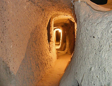
The first inhabitants of Cappadocia area have opened deep cavities within the volcanic rocks due to escape from the attacks of the wild animals and hard winter conditions and then they have enlarged these cavities according to their daily needs, they opened new cavities and created the underground cities connecting these cavities with tunnel and labyrinths. Later the underground cities were the place of the hiding of the first Christians who escaped from the persecution of the Roman soldiers and were enlarged to able when were necessary an entire city to live and every kind of fixture necessary for the living of the people has been attached. When there wasn’t any danger the people living on the ground in case of the danger have hidden in the underground cities. For this reason all the homes at that time were connected to the underground cities with a tunnel.
In all of the underground cities there are ventilation chimneys reaching place by place to a depth of 80 meters and until the underground waters. These chimneys were opened due to meet the need of both the ventilation and water. Within the cities that are tepid in winters and cool in summers there are kitchens, cribs, wine houses, depots for cereals, meeting saloons, toilets shortly every kind of living space necessary for living. Within all the cities there are locking stones which can be opened and closed only from inside against to the threats which may come from outside. Also known as Peri Bacalari.
Cappadocia Balloon Tour
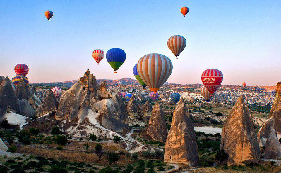 Cappadocia balloon tour begins every day at sunrise. Balloon tour takes almost an hour but if you want to join deluxe balloon tour it takes 1.30 hour. You can take your own flight certificate after tour. Comfortable clothes and shoes are recommended. You can see the deep canyons, valleys and fairy chimneys from the air.
A landscape of extraordinary beauty
Urgup (Ürgüp)
Urgup which has been established at the outskirts of the hill named as hill of whishes founded at 20 km in north of Nevsehir province in one of the first settlement areas of Cappadocia region. In the Byzantine period has been called as Osiana, Hagios, Prokopios, in the period of Seljuks as Bashisar and in the period of Ottomans as Burgut Castle. Until the first years of the Republic was called Urgup. On the way to Urgup you are greeted by “The Three Beauties” (Catalkaya). This is the best place to check out the stunning view overlooking the region.Urgup was the patriarchate center of the Cappadocia region. The Uzumlu (Üzümlü) Church, Cambazli Church and Sarica Church in Ortahisar which was one of the villages of Urgup are the oldest rock churches from the region. Furthermore and Tavsanli (Tavşanlı) Church and Church of Saint Basileious are the spectacular places. Urgup which has got the famous cave hotels, wines and hand made carpets is the most important tourism center of the Cappaddocia Region. The old cave houses were restored as a touristy cave hotel without damaging their historic structure. Among the cave hotels some of the cave have been restores as distraction place as discos and bars.
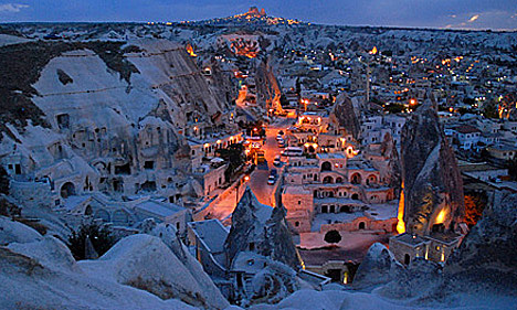
Goreme (Göreme)
 Goreme which have the old names of Korama, Matiana and Maccan is 10 km far away from the center of Nevsehir province. The valley created from volcanic rocks is famous with the chimney rocks resulting from the erosion made by the natural factors to these rocks and with the historical richness. It has been an important religious place together with the intensive emigration of the first Christians escaping from the pressure of the Roman soldiers. The population escaped from the pressures has made many abbeys, churches and houses in the volcanic rocks from the valley where they were able to hidden easily. You can go to Goreme from Nevsehir province by roadway 13 km. Nevsehir is 670 km. far from Istanbul, 280 km. from Ankara, 750 km. from Izmir.
Goreme Open Air Museum
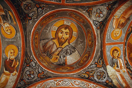
First structure is monastery of nuns at the Goreme Open Air Museum. In fact, the monastery of nuns known as six or seven floors but can be visited only three floors yet. The connection between the floors of the monastery is provided with tunnel and tunnel entrance are closed with sliding stones like underground cities of Cappadocia. There is a dining hall in the first floor, second floor has a chapel which decorated with frescoes and third floor also has a church with geometric decoration. There is Monastery of Priests near the Monastery of the nuns. Only a few rooms on the ground floor can be visited for into the rock layers are destroyed. A little later there is Hagios Basileos church which is known a tomb chapel walls decorated with frescoes. Near this church there is Aynali monastery with places around a courtyard. Aynali monastery has a big room which suppositional meeting room, a church and tomb rooms. Elmali monastery, for many years been used as a loft, all entries have been closed and thus without destroying frescoes hardly reached today. Understanding that the church is decorated in two differnet periods by means of red paint figurative decorations bottom of the poured frescoes. There is Barbara Church behind the Elmali monastery, Barbara Church walls are decorated with geometric figures and animal pictures. Just ahead Church of Hagia Katherina’ frescoes largely damaged. Yilanli church has a church, refectory, and other places. It has been named as Yilanli Church (Church with snake) for on one of the frescoes St. Georgios fight with a dragon on a horse.
Avanos
Avanos taking place at 18 km in the north of center of Nevsehir has been settled on the coast of the Kizilirmak River. Its name from antique periods is Venessa. The most important feature of the region is the manufacture of clay jugs, biscuits, and jars. The jar makers continuing since the period of the Hittites are still continuing their traditions. At the archeological diggings made in the Zank Mound near the town Sarilar of Avanos there has been discovered the ruins belonging to the different culturs from the Old Bronze Age and until to Late Roman Period. Sarihan which is 5 km far away from Avanos is one of the most beautiful examples of the classical Seljuk architecture. At Sarihan which in our days is used as a touristy place every night are made Mevlevi ceremonies.
Ihlara Valley
The volcanic eruption of Hasan Mountain led to tectonic movements that left the surface of the region covered with a layer of volcanic rock. The same volcanic activity led to pressure and heat being put upon the limestone causing it to crack and create naturally spouting springs of hot water. The structural characteristics of the region due to volcanic eruption produced tufa outcrops which were moulded by wind, erosion and other natural phenomena and created the strange and colorful Fairy Chimneys that are also encountered at Selime and Yaprakhisar. The tectonic movoments produced tufa rock that in some places is soft and in others is coloured grey, green and brown. Huge areas of crumbling rock completely covered the area in its debris. The Ihlara Valley alogside the Melendiz River is a result of this disintegration that created a canyon with a deep base. The fast flowing river is in places between 100 and 200 m deep and it divides the valley into two; it continues towards Aksaray until reaches Tuz Golu (Salt Lake). The Ihlara Valley has protected these rock-cut dwellings ad churhes with frescoes and they come down to us a unique historical treasury. These frescoed churches and dwellings easily carved into rock from the early years of Christianity are scattered all along the way from Ihlara to Selime through the Ihlara Valley.
Resources: UNESCO, NASA, cappadociaturkey.net
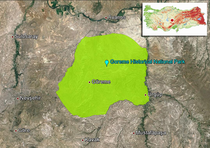
Goreme Historical National Park Map


